I think you hit a bullseye there fleals!
Texas--El Camino del Rio Drive
Date: Friday, 02. December 2011
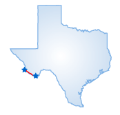
 El Camino del Rio, the River Road, leads through mountains and canyons
as it follows the Rio Grande. The 1.5-hour, 51-mile trip goes from Lajitas
to Presidio on Route 170. If you make the trip in the summer, be advised
it is extremely hot. The road is steep and has poor shoulders. Begin the
trip east of Lajitas at the Barton Warnock Environmental Education Center.
Here you can get information on the 420 sq. mile Big Bend Ranch State
Natural Area that encompasses the River Road.
Lajitas was established in 1915 as an Army post to protect settlers from Pancho Villa. Head west on Route 170 out of Lajitas. A few miles out, the road swings away from the river past Fresno Creek to the hoodoos, weathered volcanic ash formations. Madera Canyon lies nearby and features a picnic spot overlooking the river. Leaving here, you begin a five-mile, 15 percent grade ascent up Santa Mesa. An overlook at the top offers views of the canyon and volcanic landscape. Descend the mesa into the Chihuahuan Desert where you will cross Panther Creek and a narrow fissure called Closed Canyon.
Pass through Tapado Canyon on your way to the farming community of Redford. Continue west from Redford to Presidio, a former Spanish mission village that now serves as a U.S. Port of Entry. Here you can visit the Fort Leaton State Historic Site, which serves at the western Information Center for the River Road.
Starting Point:
Lajitas, TX
Distance of Drive:
51 Miles
Must Eat:
El A Jamo
Hwy 67, Presido, TX 97845
Phone:915-229-4763
Call ahead to confirm hours of operation.
Good Stop For: Mexican food
Best Time of Year for Drive:
Year round
Points of Interest on Drive:
Rio Grande
Big Bend Ranch State Natural Area
Fresno County Creek
Madera Canyon
Chihuahuan Desert
Tapado Canyon
Fort Leaton State Historic Site
Further comments to this article have been disabled.
All Comments (1)
Showing 1 - 1 comments
![]() Karess,
Karess,
